
After someone asked me about a young King’s fellow in about 1579 (whom the enquirer thought might be the minister who married Will Shakespeare and Anne Hathaway – we were not surprised when I couldn’t find any supporting evidence at King’s), I searched through that entire year’s accounts. Some surprising, or at least interesting, things came up.
The two great maps of the College site pre-Gibbs’ building are Hamond’s map of 1592 and Loggan’s map of 1688. Hamond’s map is faint, and is reproduced here as a re-drawing from Willis and Clark’s Architectural History of the University of Cambridge and of the Colleges of Cambridge and Eton. The Loggan excerpt reproduced here is taken from a 1921 reprint by Clark and Gray.
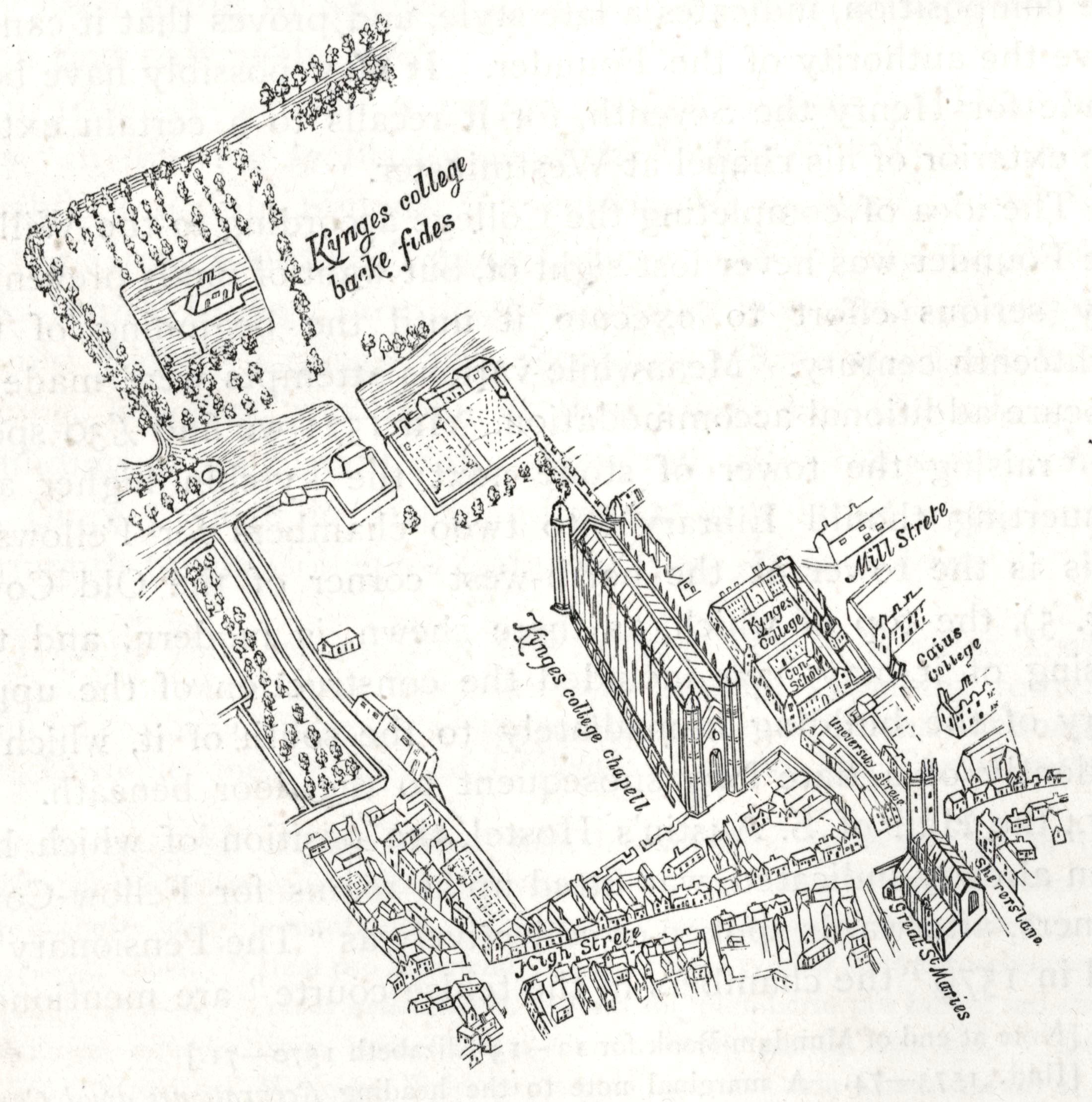
Hamond’s map

Loggan’s map
Queens’ Road (west) is at the top – the fields beyond, now the Fellows’ Garden, were common land at the time.
What’s that moated site in the middle of Scholars’ Piece? On the Hamond map it’s occupied by a dovecote. And what about all those buildings around the wall surrounding the College site, particularly visible in Hamond’s map? What are they? The draft accounts (a page of which is shown below) offer some partial explanations.

KCAR-4-1-4-11 Bursar’s particulars book, reparationes cantab. for Annunt and Bapt term (Easter and long vacation/summer) 1579
These particular pages from the accounts record repairs on the College site. (Other pages record repairs at our Grantchester and Barton estates, for example.) The first three items on this page record payments of
Junii 23 le pavier for paving 32 yerdes in the lane by the stables 2 d ob the yerde…vi s iiii d
for a load of ragge to the same…iiii s vi d
Cochei July 8° pro 10 bigatis argille…vi s viii d
The abbreviation ob is for oblus, technically a halfpenny but the term often appears in the accounts to stand generally for ‘a portion’ – in this case the paving cost works out at 2 3/8 shillings per yard. This suggests it is internal to the College site, for the 1543 Cambridge paving bill (in force until 1788) decreed that all the public streets be maintained by the frontage-holders and that ‘no persone or persones exercysyng the handecrafte or ocupacion of pavyng wythin the sayd towne, shall take above a jd. q. for every yarde square pavyng’ (Cooper’s Annals of Cambridge, vol. 1, p. 411).
Thus we paid someone to pave a lane, at two and a bit pence per yard, and he supplied the (rag-)stones at 4 shillings sixpence. We also paid Cochei for 10 cartloads of clay. It’s not clear whether this is a man called Cochei, or just ‘a coach driver’ – the designation appears in the accounts books frequently during these years, when labourers’ names are usually specified. From the marginal ‘g.w.’ next to this entry and others I surmise the clay (‘argille’), as well as the next items (sand and straw, also delivered by Cochei), were used to build the garden wall in that year. 10,800 tiles were purchased at one point to cope the garden wall ‘about the Fellows garden’ which had a locked gate.
In various places the late 1570s College accounts mention a thatched swan house and a dove house which probably housed the ‘salt stone for the pigeons’ who were fattened, like the swans, with malt – the swans were later ‘upped’ (gathered and marked) and one presumes the pigeons were consumed in Hall. Other buildings mentioned in these years are:
• the stables and stable yard
• wheat house
• wood house and wood yard
• storehouse which might be the same as the larder mentioned
• salt house
• lead house (it housed the leads used in windows and the Chapel roof I suppose)
• ‘house over the water in the Scholars’ garden’
• coal house
• mill house with mill stone and mill horse
• brew house
• bake house
• sedge house with a wall around it which might be the same as the new straw house – a boat was required to remove the scaffolding after the sedge yard wall had been repaired, so if they are the same it must be one of the riverside buildings.
Gates mentioned:
• field gate
• bridge gate
• water gate
• College gate
• alms gate
• friars’ gate
The friars’ gate was approximately where Webb’s Court gate now is. There was a tennis court outside the friars’ gate and an orchard in what is now the Provost’s garden. There were lofts somewhere for malt and fish. Willis and Clark examined the accounts and offered some explanations, but it’s likely that in many cases we will never know which buildings were used for which purposes. So there are more questions than answers at this point, and plenty more research to do in those ‘boring, dry old accounts’.
PKM

Pingback: The Potticarie’s Bill | King's Treasures